wind farms
We use specialized software to simulate the weather in a region and determine the annual net electricity production. Specialized studies for most wind farms in Romania.
read more
airports & heliports
Master Plan for the airport, technical projects, technical consultancy, details for execution planning, elaboration of feasibility studies, obstacle studies, location research
read more
geodesy, topography & cadastre
Topographical, cadastre and registration documentation, marking
more
research
ALGIS - PROJECT ACTIVITIES
Stage 1: Preparation of the theoretical base. - Completed on 30.1.2009
1. The objectives of the execution phase
The main purpose of this phase is to define the technical characteristics and performance of algorithms for vectorization and accurate determination of geographic databases. To achieve this goal has been developed the documentation "Preparing the theoretical basis".
For phase I project aimed at achieving the following objectives:
- the theoretical base preparation;
- assessing the current situation internally and internationally;
- inventory vectorization algorithms;
- inventory accuracy algorithms for testing geographic databases;
- achievement of close cooperation between the Agency for Technical Research and Technology Military and Military Technical Academy on the one hand and economic agents involved in the project, on the other.
2. Phase Summary
Because of the importance and difficulties involved, the process of automatic raster-vector conversion was a major focus of research over the past two decades. Only in recent years have become practical and commercially available software packages for automatic raster-vector conversion, but these with limitations (only automatic vector elements can be linear and polygonal with some drawbacks - linear elements represented by line discontinued or items are not identified as unit). A conversion process completely automatic raster-vector image includes procurement, processing prior linear drawing, text recognition (OCR), shape recognition, topology creation and attribute collection.
In our country there is very little discussed issue. Not have developed algorithms and software for automatic or semi-automatic collection of data mapping.
Convert raster - vector analysis is a raster image to transform it from a matrix of pixels representing a vector representation.
One of the main issues is whether vectorizării methods to have or not based on an algorithm scheletizare. A scheletizată image does not always ensure the best accuracy for the ends of lines and intersections. In view of these considerations have developed two classes of algorithms for vectorization:
- in a single step algorithms - algorithms that are directly applicable primary image;
- two-step algorithms - algorithms that have framing as the preliminary step.
While we have identified several vectorization algorithms performance, each with advantages and disadvantages, we can not conclude that a particular type of map and a detail is a good algorithm. Ideal would be to have a system to be implemented all algorithms presented, leaving the choice up to the operator of one of them, depending on experience and knowledge of parameters and applications projects.
Attribute accuracy varies within a digital map, so it is useful to determine the spatial variation of the probability of classification, not just a statistical summary.
Stage 2: field data collection (partial collection). - completed on 10.1.2009
1. The objectives of the execution phase
The main purpose of this phase is to perform measurements in the field and achieving geographic databases necessary to test the proposed algorithms. This testing will be done at a later stage. To achieve this goal has been developed the documentation "field data collection (partial collection)".
For Phase II project aims to achieve the following objectives:
- partial collection of field data;
- data processing;
- processing and analyzing data to determine the domain of values
- creating and populating databases with geographic data collected;
- achievement of close cooperation between the Agency for Technical Research and Technology Military and Military Technical Academy on the one hand and economic agents involved in the project, on the other.
2. Phase Summary
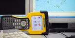
In stage II, "field data collection (partial collection)," were designed and were made for a geographic database Otopeni test area. These databases will be used in future phases to test the proposed algorithms. Therefore measurements were made (partly due to funds allocated) in the field. They used three total stations Leica TCR 407 Power measurement accuracy of 5 "and a Trimble 5700 GPS receiver with L1 and L2 frequencies with sampling rate of 5 seconds. Processing both GPS measurements and the topography were made with Trimble Geomatics Office software.
For geographical databases georelaţional model was used in which the attributes are associated with points, lines and areas. In this approach, spatial entities are linked to attributes associated with a unique identifier. Sets of attributes are stored in different attributes tables and information relevant to a spatial object are acquired through networking of two or more tables of information. The georelational model has two important features:
- reunion can be applied in both directions - giving posing attributes can be found from positioning data or position data can be found from posing a certain range of attributes;
-
attribute information in the model are associated with one or more spatial objects. Attributes that are not linked to at least one object are not normally included in the tables of attributes.
To implement this model adopts a dual strategy or hybrid data storage, with data kept separate spatial attributes, the system only maintaining links between files. Positioning data are represented by a topological model of spatial data and attributes are stored in tables in a relational database standard. For example, if ArcGIS, typical example of this approach is SHP format, spatial data are stored in files with the extension SHP
, and attribute data are stored in a database dBASE IV. The relationship between position and attribute data is stored in a file with extension SHX
.